Country: Slovenia
Mountain: Matajur
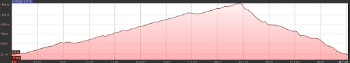
Length: 34,5 km
Elevation gain: 1480 m
Maximum elevation: 1640 m
Technical difficulty: 4/5
Download GPS Track: Matajur_Cyclotrail
Date of ride: 05.08.2019.
Suitable for E-bike: Yes


After paved road we reached gravel road that goes through pastures filled with cattle. The road is not very steep, but we were tired because we cycled for few days in a row. After gravel road comes very nice singletrack with views on top that leads to hut. There we rested a bit and enjoyed fresh air. Too bad that hut didn’t work. From the hut, we didin’t go right as classic Matadown trail goes, we went left. It is more demanding, and it is not entirely rideable, but offers better views which is better for my taste. You can follow the trail on the right because it will connect after few hundred meters with ours.
This trail is voted for one of the best trails in Europe, and you can see why. Very long singletrack descent with great views on local mountains in all directions. The trail is diverse, and begins with a steep and rocky part that push to the limit both bike and rider’s strenght. After the fields before Glevizza’s pass we jump into the middle part really flow with some technical passages and counterslopes. Almost at the end of the trail I realized that I forgot to unlock my shock and fork (all the time I thought I was tired because of the rides from previous days :D).
At 30th km we turned left on the turn because we didn’t want to go back with the road to Savogna so we didn’t ride matadown all the way. If you want, you can go straight ahead. Trail on the left that goes to Savogna is visible from 7:33 ni the video. All in all, one of the best descents, and I will sure come back and do this trail again.
Map of route:
Elevation profile: